Ha`ena Home Hawaiian Islands Home Pacific Worlds Home

Arrival

Native

The Sea

The Land

Footprints

Visitors

Memories

Onwards

Ha‘ena Home |  Our Guides |  Location |  Orientation |  Getting Here |  Credits
   
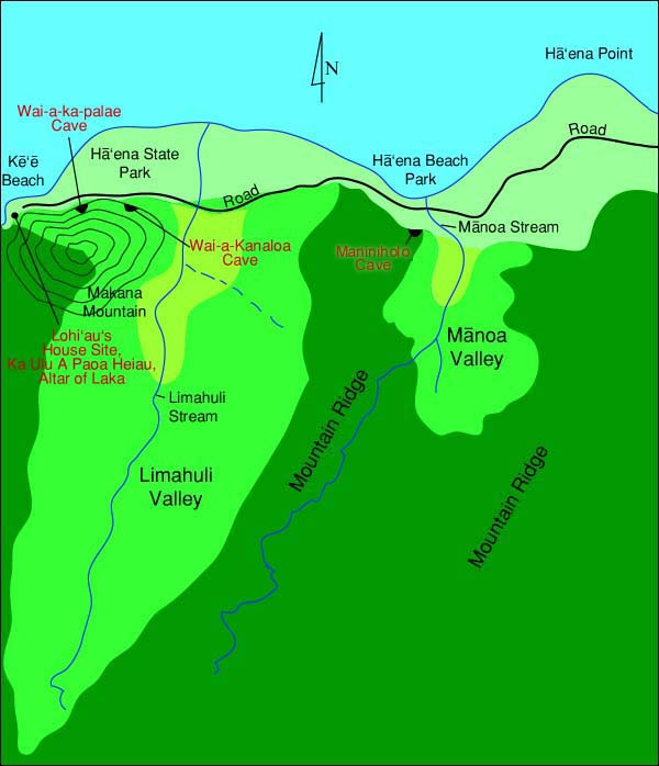
Orientation to Ha‘ena


The ahupua‘a of Ha‘ena encompasses two valleys: the shallow valley of Manoa ("thick") and the deeper valley of Limahuli ("turning hand") are separated by Ka-iwi-ku‘i Ridge. Though Manoa valley was clearly used for both agricultural and ritual purposes, the much larger Limahuli valley dominates the landscape of Ha‘ena. Each valley has a permanent stream. Three caves--two wet and one dry--are among the many storied places from ancient times. Today, the area is mostly noted for two park areas, and the National Tropical Botanical Garden that occupies most of Limahuli Valley. Near Ke‘e beach begins the Kalalau Trail, a 10.5-mile hike along the dramatic Na Pali coast.


Ha'ena Orientation Map


Because of its historical importance and its importance as the major site of habitation and agricultural production up until recent times, the area encompassing Ke‘e Beach, Ha‘ena State Park, and the mouth of Limahuli Valley receive the most detailed treatment in this study.

Changes in transportation technology and land use today leave Ha‘ena at the far end of Kaua‘i from the centers of commerce and activity. Though it is a very much visited locale, famous for its beauty, beaches, and access to the Na Pali coast trail, today one undertakes an adventure in getting here.


Ha‘ena Home |  Our Guides |  Location |  Orientation |  Getting Here |  Credits
Arrival |  A Native Place |  The Sea |  The Land |  Footprints |  Visitors |  Memories |  Onwards
 
Map Library |  Ha'ena Site Map |  Hawaiian Islands Home |  Pacific Worlds Home


PREL

HCH

HGA

HGA