|
|
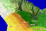
Areas
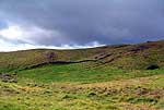
The different zones of Kawaihae are considered. Although there is a
long stretch of elevation from the sea to the top of the mountain, the
dryness of the Kawaihae area limited the types of usage zones found
here.
|
|
|
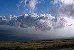
Winds
Kawaihae is famous for two conflicting winds: the Mumuku
wind from the uplands, and the Naulu wind from the sea. Residents
today still speak of the changing winds of Kawaihae.
|
|
|
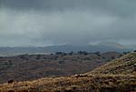
Rains
Kawaihae is the driest place in the entire Hawaiian Island archipelago.
Known in the past for the "cloudless rain," Kawaihae is better
known to its residents to day as a place of almost no rain whatsoever.
|
|
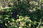
The Forest
The range of elevations going up the Kohala mountain once gave
Kawaihae a rich range of vegetation zones. Wet forest still remains
high atop the mountain. Various species and practices are discussed.
|
|
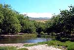
Water
The streams of Kawaihae are mostly intermittent, running only during
the rainy season, and not always even then. Residents tell of the different
waters from upland streams to coastal wells and pools.
|
|
|
Planting
Much of the agricultural production took place in Kawaihae Uka, as discussed
in the Native Place chapter. Here, residents
talk about what they grew down in coastal Kawaihae, and different foods
they made.
|