Makana Haena Home Hawaiian Islands Home Pacific Worlds Home

Arrival

Native

The Living World

Sustenance

Health

Footprints

Visitors

Memories

Today

Onwards

         Areas  |  Seasons  |  Forest  |  Ocean  |  Sky  |  Language  |  Sources & Links
   
a href="liveworld.htm">Living WorldAreas


Areas

Map showing the different areas that comprise Hā‘ena ahupua‘a, as described by Chipper Wichman.

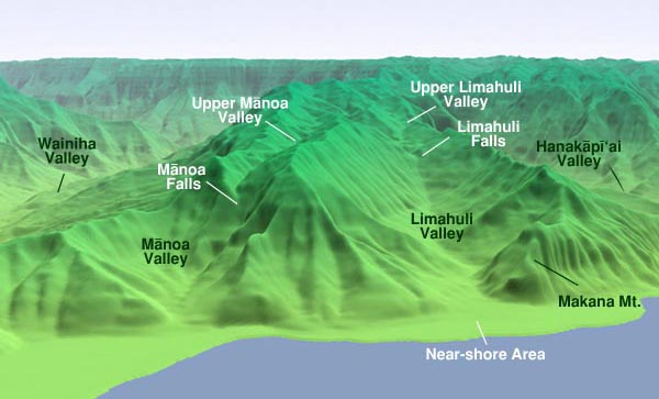
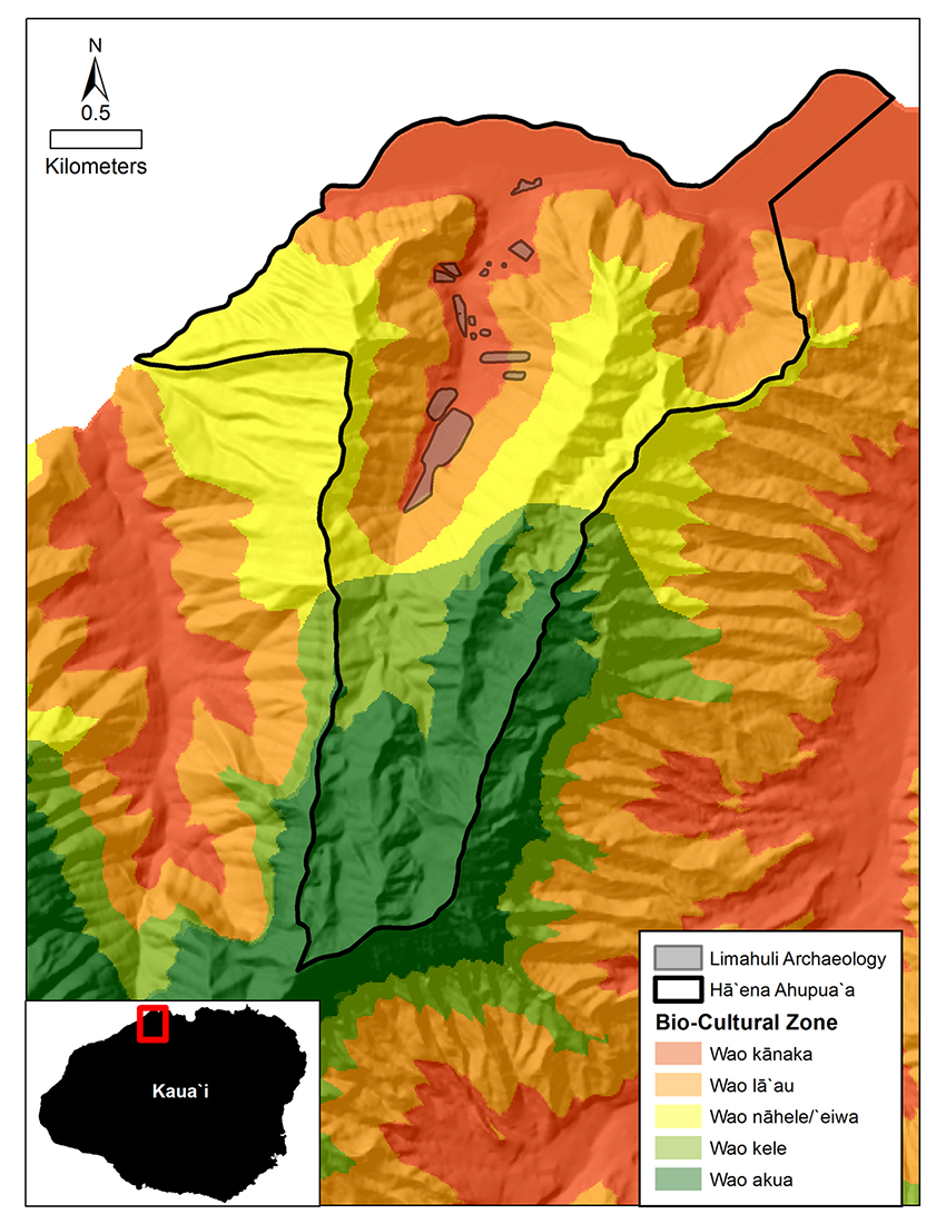
There are different ways of categorizing the environmental areas in Hā‘ena. Chipper Wichman, who previously managed Limahuli Valley's National Tropical Botanical Garden, identified three general zones:

Nearshore Area

The alluvial plane between Limahuli Valley and the sea.


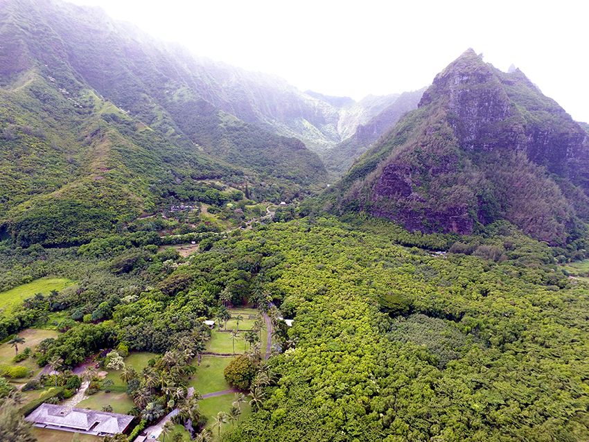
The Near-Shore Zone:

“Out in front of the valley, there is a nice alluvial plain, that's perfect for development of a large lo‘i complex—especially down in the Kē‘ē area. This zone we tend to believe was probably the primary zone of habitation—where most of the house sites were located, close to the marine resources, often clustered around fresh water sources like Limahuli stream.

“There are a number of springs that come out from the base of this mountain here, along this cliff, as well as springs down here. Mānoa stream may have run more perennially in the past, and there are springs along the beach, which come out underwater. And there are some oral traditions that they would actually dive down and get fresh water out from the spring under water.”

Limahuli Valley

Lower Limahuli Valley, showing some of the restored taro lo ‘i.

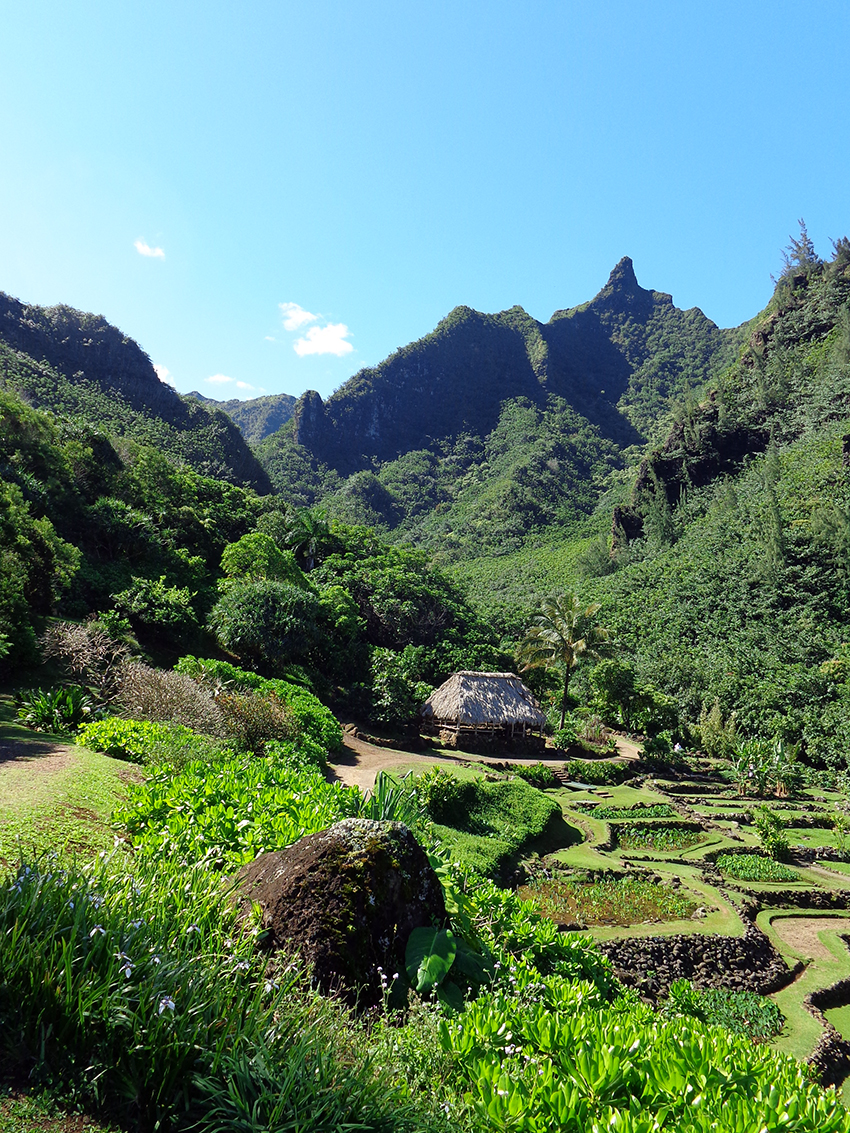
The Lower Valleys:

“The valley habitat is sometimes referred to as the kula area, although ‘kula’ in many of the other ahupua‘a of the islands refers to really upland areas, especially going up on the slopes of the larger mountains. In this case, we're talking about the valley, and especially the areas bordering the stream and the little tributaries that come down.

“This area was pretty intensely used for lo‘i development, with other types of agricultural work areas where they had some kind of shelters developed. Especially in the back there for harvesting ‘olonā, wauke, and other products where it would have been actually more efficient to harvest them and do some processing back there, further up in the valley.”

“Wauke, and ‘olonā especially, still grow wild back in the valley, generally along all the waterways and tributaries, but in ancient times it was a cultivated plant, because of its fiber. It produces the strongest fiber of any natural product in the world. In fact, the ship captains used to come all the way to Hawai‘i to get ‘olonā rope, prior to nylon being invented, because it produces the strongest fiber. Even Swiss mountain climbers were said to prefer ‘olonā rope. But in the ancient days of course, it was of major importance, especially for producing fishing tackle, because a net made with 'olona, or fish lines with ‘olonā, would allow you to harvest much greater resources.”

Limahuli Falls

Limahuli Falls spills from the upper valley into the lower valley.

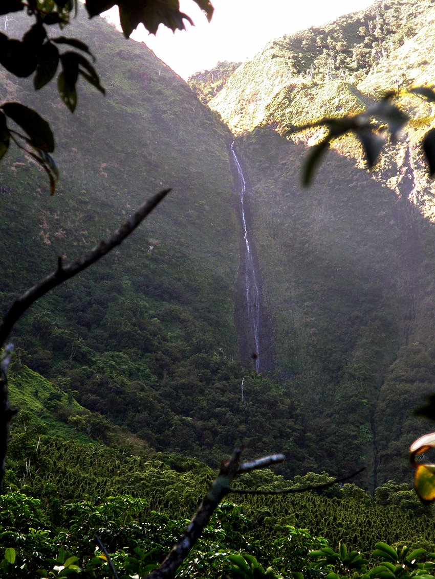
The Upper Valleys:

“Up above this zone in the lower valley, which extends all the way up to Limahuli Falls, we then have an upper zone, which is above the Limahuli Falls, and extends from about 1600 feet elevation, up to about 3300 feet, and that's the top of the ahupua‘a.

“In this area we have found banana, taro, growing back up in there. It indicates to us that the Hawaiians were back up in there, utilizing it as a resource area, with no indication at all of any kind of structure or stone work. So whatever dwellings they constructed, they were probably just lean-to types of structures that were perishable and were used for just a week or however long they were back up in there.

“I imagine that area was primarily used by the bird catchers to harvest the birds. And maybe some of the kahuna lā‘au lapa‘au, maybe there were some medicinal plants that grew up in that area that they needed. But generally, the plants that grow up in that area, for the most part, grow in the lower valley. Because of the rainfall regime, we have a transition of lowland rainforest that comes nearly down to the ocean.”


Kawika has recently done research on traditional land-use designations: “In Hawaiian language there are the different wao terms—like wao akua, which is the sacred forest—and there’s all of these different zones. Wao, in my understanding, is like a biocultural zone. It dictates what kind of engagement is okay for that area, or what kind of engagement is not okay for the area. It’s tricky because it’s important to remember that before Kamehameha unified most of the islands, each island was its own separate kingdom. And each separate kingdom had its own calendar, it was different than the other kingdom’s calendars. They had different systems for managing resources. So they were similar, but the system on Hawai‘i island was different on Maui, it was different on O‘ahu, it was different here and other islands.

Ka Lama Hawaii

Front page of the first issue of Ka Lama Hawaii, the first Hawaiian-language newspaper.

"“So part of the challenge is that most of the documentation of how this was managed comes from the island of Hawai‘i. There were three famous Hawaiian historians who documented these kinds of things, but they are all from Hawai‘i Island.

"And so I know enough not to transplant a Hawai‘i-Island system to the island of Kaua‘i. Historically, there have been tensions in the relationship between the two islands and it would be very insulting to the cultural history of Kaua‘i if I were to just come in with these Hawai‘i Island ideas. And so what I did, I kind of just took the assumption that this is a similar system, but applied it in a different way. So how was that applied here?

“Luckily for us, all of our Hawaiian-language newspapers—published from 1836 to 1942—documented so much amazing knowledge, and they’ve all been digitized now. So I did word searches for wao and Kaua‘i and different iterations or word combinations and it came out at least five wao's that we used on the island of Kaua‘i historically, and there may have been more.

"We looked at these five different wao, and then using GIS technology and this cultural knowledge, and looking at our knowledge of the valley, we created this GIS model which show these five wao cultural zones. Which has been really amazing for us to understand what is a culturally appropriate way for us to engage with forest restoration.

"Looking at an area that is historically very intense human activity in a forest, to try and approach forest restoration in that area and make a pre-human forest type. There are areas that are appropriate to do that, so where are those, and it just kind of dictates restoration actions and how we approach it.”

Here are Kawika’s descriptions of the five different social-ecological zones, or wao, that he and his team identified for Kaua‘i, and for Hā‘ena in particular:

Five Wao Map

GIS Map of the five Wao. From Winter & Lucas, 2017.


Wao kānaka: "Primary function of this zone is landscape-scale augmentation to maximize availability of food, medicine, and housing. This zone allowed for (but did not mandate) conversion of forest to field agriculture, aquaculture, habitation, recreation, and/or temple worship. Native and introduced trees were tended, individually or in groves, for regular and specific cultural services. Within Limahuli Valley, this ‘intensified human-use zone’ encompassed the majority of the mapped Hawaiian archaeological sites.

“Although the wao kānaka designation was intended to zone an area as acceptable for potential augmentation of the landscape, as a means to maximize the availability of food, medicine, and other key resources, under some circumstances leaving areas as forested in the human realm constituted their highest and best use. An example of this is the coastal hala forest of Naue, which was famous for the weaving material that it produced. This coastal forest of intensified human use was honored in the ali‘i era and remained both intact and intensively used by the community at the eastern border of Hā‘ena until it was wiped out by the tidal wave of 1946.

“The concept that forested areas existed within the wao kānaka zone of the ali‘i era is worthy of further exploration. Forested areas remaining within the zone of human usage might have made these areas more practical to manage for timber and non-timber forest products, as with the example of the hala forest of Naue discussed earlier. This could be because the cultural and/or religious protocols (e.g., chants, prayers, offerings, etc.) associated with entering a different social-ecological zone might not have been required before entering the wao kānaka forest to tend, gather resources, or otherwise enjoy the space. Given the known existence of forested areas within the wao kānaka, and the fact that there is no evidence that deforestation was an accompanying mandate of this designation, it is safe to assume that large areas of forest existed within this zone through the end of the ali‘i era.

Wao lā‘au: "Primary function here is to maximize availability of timber and non-timber forest products. This zone allowed for management of a highly tended forest via an integrated agroforestry (native and introduced plants) regime, producing native and introduced hardwood timber. Also found here are introduced food trees, and native and introduced biofuel sources. In this zone, native biodiversity was maximized for nontimber forest products, including cordage and weaving material, medicine and dyes, ceremonial plants and adornment plants.

“This social-ecological zone has to be logistically feasible for perpetual forestry (i.e., timber and non-timber forest products) management and extraction. As such, the wao lā‘au shares its lower border with the upper boundary of the wao kānaka. Within Limahuli Valley we delineated this zone by mapping existing groves of Polynesian- introduced kukui trees from high-resolution Pictometry. Kukui trees were chosen because of their known ethnobotanical value and role in agroforestry by Native Hawaiians, as well as their easily distinguishable light green leaf color. The upper boundaries of this zone are are where impassable landscape features such as cliffs and extreme slopes would not permit this management activity."

Valley View

A view into Limahuli Valley, with the upper valley in the far back. Compare to the map by Winter and Lucas, above.

Wao nāhele/ Wao ‘eiwa: "The wao nāhele zone is ecologically aligned to dry and mesic moisture areas. This zone’s primary function was to maximize suitable habitat for native birds. It is a forest zone that was minimally tended—generally remote upland, mesic forest—and left as a native-dominant plant community. It was impractical for access except by bird catchers and feather gatherers. The zone is otherwise beyond the practicable area for resource management and extraction."

Wao kele: "This is an untended forest zone associated with core watershed areas (remote upland, wet forest below the clouds) that was left as a native-dominant plant community. It was impractical for access except for transit through via trails.

“This zone is similar to the wao nāhele. It is ecologically defined as areas of wet forest beyond the realm of feasible, intensive forest resource management. Thus moist-to-wet and very-wet ecological zones serve as the factor separating this wet zone from the dry wao nāhele. In dry areas, the lower boundary of this zone is shared with the wao nāhele, but in wet areas the upper boundary of the wao lā‘au serves as the zone’s lower boundary. Both of the wao kele and wao nāhele upper boundaries are always defined by the lower limit of the wao akua."

Wao akua: "Designated as ‘sacred forest,’ this was a restricted forest zone for a native-only plant community. It thus serves as a perpetual source population for endemic biodiversity. It is associated with montane cloud forest, elfin forest. We delineated the lower boundary of this zone by estimating where clouds form and intersect the landscape on Kaua‘i."


The location and configuration of the valley connects directly to the effects of the seasons in Hā‘ena.


Living World Areas   |  Seasons  |  Forest  |  Ocean  |  Sky  |  Language  |  Sources & Links
Arrival |  A Native Place |  Living World |  Sustenance |  Health |  Footprints |  Visitors |  Memories |  Today |  Onwards
 
turtle

PREL

HCH

HGA

NMAI logo

USFS Logo