 |
 |
 |
|||||||||||||||||||||
|
|
|
|
|
|
|
|
|
||||||||||||||||
|
|
|||||||||||||||||||||||
|
|
|
|
| The records of the Mahele paint a complicated picture of this area. "When the Mahele was done, they didn’t have surveyors," Stephen explains, "so all the transactions recorded in the Mahele book use the traditional names." Yet claims were filed that identified either Honolulu, or Nu‘uanu, or Luakaha as the ahupua‘a. We are certain today that "Honolulu" was the ahupua‘a. So Nu‘uanu was clearly distinct from Honolulu-the-city, even in the mid 1800s when the "city" was not much more than a small town; and Luakaha was a special area with its own distinct identity. The claims for Honolulu are overwhelming: 1,399 individual claims were filed, showing the intensity of use and occupation in this area. Given this overwhelming data, we are choosing again to focus our attention on Nu‘uanu. For those who wish to explore the claims in Honolulu, we invite you to use the Waihona ‘Aina website. Log in as a guest and enter "Honolulu" as the ahupua‘a. |
||
|
||
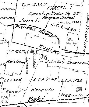
| Within the valley itself the density of claims is still very high. This attests to the importance of Nu‘uanu as both an agricultural region and as an area in which Honolulu residents, including chiefs and foreigners, held lands. Below are presented selected tables of claims identifying locations within the ahupua‘a of Honolulu that lie in the area mauka (uphill) from Honolulu downtown. These are a small sample of the many claims for this valley. To view more claims by subsection (‘ili), use the interactive map. Each table will open in a separate window. Maps of the claims in these subsections are accessible below.
|
Interactive Map:
|
|
|
||
| Table I:
|
||
| LCA | Claimant | Island | District | Ahupuaa | Ili | Awarded |
|---|---|---|---|---|---|---|
| 00008! | Hall & Johnston, R. | Oahu | Kona | Nuuanu |
No |
|
| 00085 | Phillips, Thomas | Oahu | Kona | Nuuanu | Kaimuohena |
Yes |
| 00112 | Carter, Joseph O. | Oahu | Kona | Nuuanu | Kawananakoa |
No |
| 00145 | Vonpfister, John | Oahu | Kona | Nuuanu |
No |
|
| 00251 | Kaumaka, wahine | Oahu | Kona | Nuuanu | Haipu |
Yes |
| 01973 | Kealoha | Oahu | Kona | Nuuanu | Kaloiki |
No |
| 02114 | Kapalau | Oahu | Kona | Nuuanu | Laimi |
No |
| 05668 | Kalawaiaaku | Oahu | Kona, Koolaupoko | Nuuanu, Kailua | Luaka, Manu |
No |
| 05743 | Kapahi | Oahu | Kona | Nuuanu | Palikea |
Yes |
| 05794 | Kawahapala | Oahu | Kona | Honolulu, Nuuanu | Kaukahoku, Kapaeli |
Yes |
| 05988 | Maiao | Oahu | Koolaupoko | Kailua, Nuuanu | Kaluainanea |
No |
| 08427*O | Kapakuhaili, Hazaleleponi | Oahu | Kona | Kalihi, Nuuanu | Church St., Luakaha |
No |
| 09925 | Lonoaea | Oahu | Kona | Nuuanu | Kawananakoa, Kaolu |
Yes |
| 10182 | Molina | Oahu | Honolulu | Nuuanu | Palikea |
Yes |
| 10219 | Mauae | Oahu | Kona | Nuuanu | Kului, Kapohuluhulu |
Yes |
| 10604 | Puaanui | Oahu | Honolulu | Nuuanu | Puunui |
Yes |
|
|
||
| Table II: |
||
| LCA | Claimant | Island | District | Ahupuaa | Ili | Awarded |
|---|---|---|---|---|---|---|
| 00005 | Pelly, George | Oahu | Kona | Honolulu | Luakaha |
Yes |
| 01469 | Kaolola | Oahu | Kona | Honolulu | Luakaha |
No |
| 01479 | Kaumi | Oahu | Kona | Honolulu | Luakaha |
No |
| 01483 | Kukoa | Oahu | Kona | Honolulu | Luakaha |
No |
| 02818 | Kawaa | Oahu | Kona | Honolulu | Luakaha |
No |
| 02830 | Kaneiakama | Oahu | Kona | Honolulu uka | Luakaha |
No |
| 03163 | Paki, A. | Oahu | Kona | Honolulu | Kawananakoa to Luakaha |
No |
| 08427*O | Kapakuhaili, Hazaleleponi | Oahu | Kona | Kalihi, Nuuanu | Church St., Luakaha |
No |
| 08515*O | Ana, Keoni, Young, John | Oahu | Kona | Honolulu, Waikiki | Queen St., Luakaha, Pahoa |
Yes |
|
|
||
| Table III:
|
||
| LCA | Claimant | Island | District | Ahupuaa | Ili | Awarded |
|---|---|---|---|---|---|---|
| 02754 | Nakahaulu | Oahu | Kona | Luakaha | Kahuawai |
No |
| 02757 | Naluawai | Oahu | Kona | Luakaha | Kaluahonokoi |
No |
| 08859 | Kaneuelani | Oahu | Kona | Luakaha | Kaluaolohe |
No |
| 08860 | Kanaha | Oahu | Kona | Luakaha | Waipi |
No |
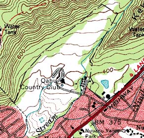
| The claims in the lower part of the valley include a number of haole (foreigners). This is also true in some areas within the middle and upper reaches of the valley. But in many other portions of the valley, agricultural use continues to be prominent at the time of the mahele. The 1885 map use here shows the density of agricultural fields, and also the density of Mahele claims.
|
||
| |
||
 |
|
|
||
|
With the change in ownership also came a shift in naming and defining land. At the time of the Mahele, there were few Western-trained surveyors to mark out and map the boundaries of these new private holdings. Largely it was done by name, and by traditional descriptions. "Picture Kamehamhea III, Kauikeaouli, sitting there with all these chiefs--who are war chiefs, powerful men--lined up to sign the Mahele book, agreeing to his sovereignty over all their lands, and he’s agreeing to have them rule over their lands," Stephen describes. "And all they had was their signature and the name of the ahupua‘a recorded in the book. Basically that’s what the Mahele records. This tells you that the ahupua‘a system was very stable, that the people understood: this ahupua‘a is governed by this chief, and he signed in the Mahele book with the King. "
|
||
|
|
||
|
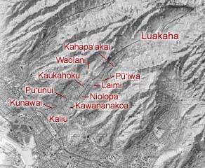
"After that," Stephen continues, "the Land Commission went around and gathered testimony for the further subdivisions, and based on those testimonies we have all the descriptions, within those ahupua’a." As can be seen on the lists of claims filed, land parcels are identified by ‘ili. This shows the nested structure of places and place names by which Hawaiian culture maps out territory. This oral map was meaningful in the mid 19th century, but by today, many of these place names have been lost. How did this happen? This is a matter of shifting the "sense of place" from a Hawaiian oral mode to a Western, cartographic mode. One can see by looking at the older maps and comparing them to the newer maps, how place names have lost their context. Many of the names, such as Ahipu‘u, La‘imi, Pu‘iwa, Niolopa, and Kawananakoa remain as street names, and so retain some geographic relevance today. But the name "Luakaha" remains only because there is a property that retains that name. Place names such as Kahapa‘akai and Kahaukomo have no context anymore.
|
|
|
|
Partly this shift occured because it was foreigners, not Hawaiians, who were constructing the maps. It was a gradual change, for many old maps do retain a large number of Hawaiian place names. But these diminish after the Islands become a U.S. Territory. Coulter’s (1935) gazetteer of place names states as follows: "The names of many geographical features in the islands known to the Hawaiians are not given in the gazetteer. There are in the office of the Surveyor of the Territory maps of parts of the Hawaiian islands with unimportant features identified by name. The Hawaiians named outstanding cliffs, rocks, small streams and gulches, and some trivial land marks. Such names were thought not to be of enough importance to include in the work. Mr. A.O. Burkland, during his supervision of the United States Geological Survey ... chose the more important features to be named on the topographic sheets and the most authentic names."
|
|
|
|
|
The shift in naming is but one of the changes brought on by the Mahele. The other, more important change is in the notion of property. A conflict between Western and Hawaiian perceptions characterizes the society in Nu‘uanu at that time.
|
||
|
|
||
| |
| |
|
|
 |
| Nu‘uanu Home | Map Library | Site Map | Hawaiian Islands Home | Pacific Worlds Home |
|
|
|
|
|
|
|
|||
| Copyright 2003 Pacific Worlds & Associates • Usage Policy • Webmaster |
|||