 |
 |
 |
 |
||||||
|
|
|
|
|
|
|
|
|
|
|
| Areas | Seasons | Forest | Ocean | Sky | Language | Sources & Links | |||||||||
 |
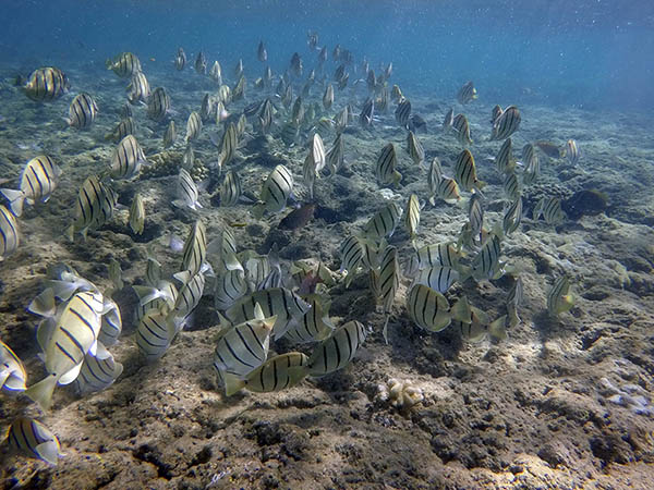
A school of manini on the reef at Kē‘ē Beach. Hā‘ena's beaches are well described in John Clark's book, "Beaches of Kaua‘i and Ni‘ihau" (Honolulu: University of Hawai‘i Press, 1990). He explains that there are two major beach areas, now defined as Hā‘ena Beach Park and Hā‘ena State Park: Hā‘ena Beach Park: "Hawaiian fishermen know the beach and bay at Hā‘ena Beach Park as Maniniholo, the ‘travelingmanini fish.’ In former times, this area was a popular hukilau site, particularly during the months of July and August when the ocean is usually calm. "The wide bay offshore is bordered by two large reefs, Makua Reef to the east and Hauwa Reef to the west, but no reef protects the beach itself. It is completely exposed to the open ocean. During periods of high surf, particularly during the winter and spring, waves funnel unchecked directly onto the beach, creating very dangerous water conditions, particularly a pounding shore break, a strong backwash, and powerful rip currents. The foreshore of the beach is always steep, a good indication of the erosive force of the annual high surf. Over the years Hā‘ena Beach Park has been the site of a number of drownings and many near-drownings. Swimmers and body surfers in the shorebreak are usually the victims." Hā‘ena State Park: "Like many other north shore coastal areas, this beach is protected by a number of well-developed fringing reefs, all of which were important to Hawaiians for fishing and gathering. The Hawaiians gave place names to all of their food gathering sites, some of which are still remembered. Hauwa is the large, very shallow reef that begins at the western edge of Hā‘ena Bay; surfers call it Cannons. The waves that break here are so hollow that they often "spit" out a blast of compressed air and sea spray, and early surfers who rode the break likened the blast to the firing of a cannon. Inshore of Hauwa is a rock formation on the sand that was known as Halepohaku." This is the same Hale Pohaku that Chipper described. "The next reef is Pu‘u Kahuaiki; the surfing spot there is called Bobo's.... To the west is another reef, Pu‘u Kahuanui, portions of which are emergent even at high tide." Kahuanui was Lōhi‘au's sister, and this surfing area was her domain. It is here that Lōhi‘au went surfing shortly after Hi‘iaka brought him back to life. There is also a wind named for this surfing area discussed in the "Land" chapter. "The channel cut through the reef by Limahuli Stream was called Poholokeiki....The large fringing reef offshore was known as Ka‘ilio, the eastern end being Ka‘ilioiki and the section at the point, Ka‘ilionui." It is suggested elsewhere that Ka-‘ilio ("the dog") actually refers to the endemic Hawaiian Monk Seal, called ‘ilio-holo-i-ka-uaua." Ke‘e Beach: At Ke‘e ("avoidance"), the reef ends in a small, sand-bottom lagoon separated from the ocean by a shallow but wide reef flat. This lagoon makes Ke‘e a popular swimming and snorkeling site,though during periods of high surf--winter and spring--dangerous water conditions occur near shore: "At such times, powerful rip currents run out to the sea through a channel penetrating the western end of the reef flat. Over the years, this channel has been the site of a number of drownings and many near-drownings. During periods of calm seas, spear fishermen, kayakers, and snorklers occasionally use the channel to reach the open ocean beyond the reef." Na-hiki, "many arrivals" -- is the bay by Ka-ulu-a-Paoa heiau. Frederick Wichman says the students "had to swim the lagoon, go out the channel into the ocean, and come ashore at Nahiki where, even on calm days, the waves surge fiercely in and out. In so doing they passed the shark that was fed by the chiefess. Those students who had broken any rules were devoured by it. Those who were without fault came ashore safely." 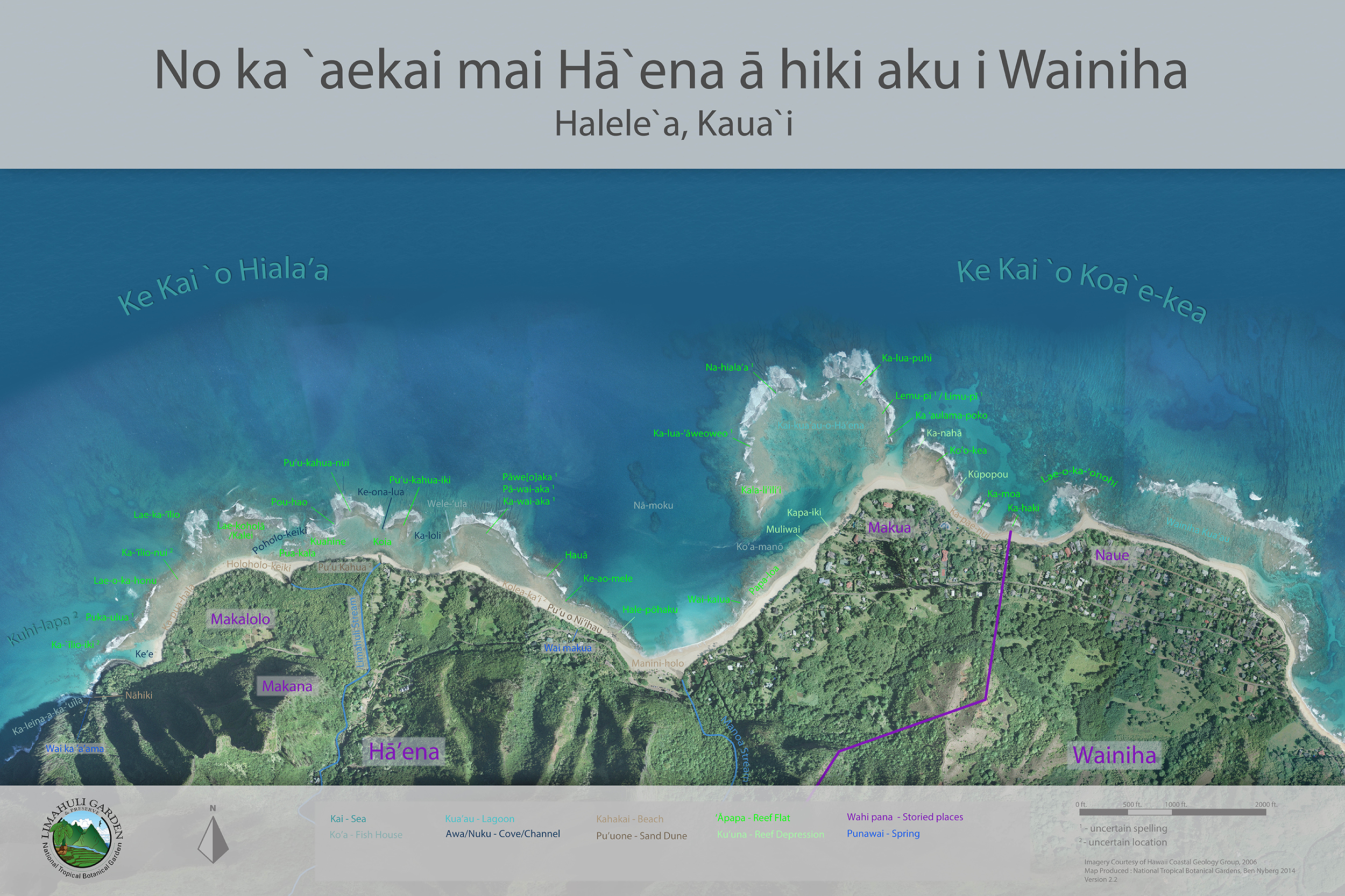
Uncle Tom explains the importance of Place Names in the ocean: “When I was fishing, my dad used to say that for me to learn that, I got to know the name of the places. He would tell me ‘Eh, son, there’s a big pile of moi!’ I would go straight over there, look over, go look for that moi. And see them. Like for example like when we go catch moi we go over here Pu‘u Kahuanui and Pu‘u Kahuaiki, that’s where the moi going come pile up over there. Like if my dad see the fish and we not around he tell us, ‘Eh, boys you know down Pu‘u Kahua get big pile moi, go down there and go look for it.’ And we’d go right over there go look for ‘em. “But you know, all these places, after learning here and there what my Dad was trying to tell me, I would go research myself and go look all these place names. Now if I collect the fish over here, where the fish going? The next place where I can get them again, if I need.” “You know there was life for me, learning all these ‘āpapa names and stuff—learning all the words from my Dad. ‘Āpapa is the reef. And then the kū‘una is the channel, the place for us to block and catch the fish. That’s called kū‘una. And in Hanalei, we do them day or night. And I know, anybody else outside of me, never did do that before. But I did it at the young age, that’s when my life started. My Dad was an expert fisherman. He knew this whole place over here from the old Hawaiians. And we were always learning.” “Over the years, from when I was young you know, one teenager, we used to go with my dad. And then what we wished, that my dad wouldn’t get the fish so that we don’t have to carry that weight all the way from there till we’re by our car. Once my brother and I got a hook, dragged the fish, all go home in the bag, and we dragging the fish and crying at the same time, because the fish is heavy, yeah? I’m not kidding you, that’s what happened. When we were young you know, four or five years old.”
|
|
|||||||
|
At the edge of the Ocean, and inland, and above and beyond, stretches the sky and its inhabitants.
|
|
||
|
|
||||

|
|
|
|
|
|
|
|
||||
| Copyright 2018 Pacific Worlds & Associates • Usage Policy • Webmaster |
||||