 |
 |
 |
 |
||||||
|
|
|
|
|
|
|
|
|
|
 |
|
||
|
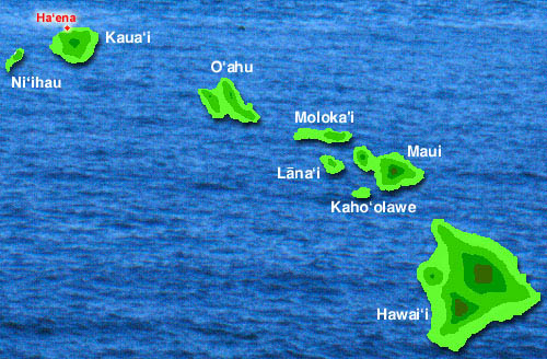
Location of Hā‘ena | |
|
|
|
|
|||||||
|
Kaua‘i is the Northwestern-most of the eight major Hawaiian Islands. It is separated from O‘ahu, the population center of the Hawaiian Islands, by the wide ‘Ie‘iewaho Channel. This geographic barrier made for a distinctive culture and history on Kaua‘i, and its character as "a separate kingdom."
|
|
|
|
|
|
|
|
|
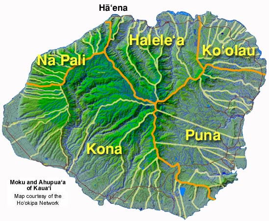
Within the Island of Kaua‘i, Hā‘ena resides in the Halele‘a district of the North. Kaua‘i was divided into five major districts (moku ‘aina) that correspond roughly to contemporary administrative divisions. Hā‘ena lies at the Western end of Halele‘a, where the lowland plain yields to the rugged cliffs of the Nā Pali Coast plunging into the sea. Beyond Hā‘ena, settlements nestled in secluded valleys are accessible only by windy trails along steep slopes or by boat. Still today, the road ends at Hā‘ena.
|
|
|
|
|
|

|
Click Here to view the large-file ahupua‘a map of Kaua‘i developed by the Ho‘okipa Network (thanks, Ken and Pua!). It will open in a separate window. |
|
|
|
Want to see an 1824 map of Kaua‘i? This one shows the moku‘aina and ahupua‘a, using T's and R's in the spelling. Map courtesy the Kaua‘i Museum.
|
|

|
Now that we know where Hā‘ena is located, let us get some orientation to this land division.
|
|
||
|
|
|
||

|
|
|
|
|
|
|
|
||||
| Copyright 2018 Pacific Worlds & Associates • Usage Policy • Webmaster |
||||