 |
 |
 |
 |
||||||
|
|
|
|
|
|
|
|
|
|
 |
|
||
|
He‘eia, O‘ahu: Map Library |
|
|
|
The maps used in this site are arranged according to the chapter and subsection in which they are found. A short description is provided to enable you to ascertain which map most closely serves your needs. Clicking the dog petroglyph will open the image only, in a separate page.
|
|
|
|
|
|
Link: |
Description: |
Page: |
|
|
|
GoogleEarth image showing the location of the Hawaiian Chain. |
|
|
|
|
The location of He‘eia within the Hawaiian Island chain |
|
|
|
|
Map of the moku and ahupua‘a of O‘ahu. |
|
|
|
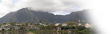
Overview of He‘eia ahupua‘a |
|
||
|
Key landmarks in and around He‘eia frequently discussed in the text |
|
||
|
Three routes from Honolulu Airport to He‘eia. |
|
||
|
GoogleMaps 3-D image of Hiva Oa, in the Marquesas |
|
||
|
The relative locations of O‘ahu, Tahiti (Society Islands) and Hiva Oa (Marquesas). |
|
||
|
Map showing the distribution of sewn-plank boat construction in the Pacific basin |
|
||
|
Points mentioned regarding the overall territory of He‘eia |
|
||
|
Lyons and Brown's 1872 map, showing the boundary of the ‘ili of Mōkapu |
|
||
|
|
GoogleEarth Map of the Ko‘olaupoko district of O‘ahu |
|
|
|
View from from the Nu‘uanu Pali of reference points in and beyond He‘eia. |
|
||
|
Googlemap image showing how development drops off going from He‘eia towards Kualoa. |
|
||
|
1882 map showing fish ponds around He‘eia and Kāne‘ohe |
|
||
|
Aerial Survey of Mōkapu Penninsula for Kāne‘ohe Naval Air Station, 1939 |
|
||
|
1882 map by Geo. Ed. Gresley Jackson showing the extensive fish ponds of Mōkapu |
|
||
|
Annotated GoogleMaps image of the end of the Mōkapu penninsula, 2019 |
|
||
|
|
Portion of W.A. Wall's 1899 map that shows the location of a water hole |
|
|
|
|
Interactive map of sites on Mōkapu |
|
|
|
A simplified chart of some common Hawaiian area terms |
|
||
|
1897 map showing ‘ili ‘āina names. |
|
||
|
Streams and major water sites in He‘eia |
|
||
|
Locations of ‘Ewa and He‘eia ahupua‘a. |
|
||
|
Locations mentioned in the story of Laka. |
|
||
|
Locales on O‘ahu regarding chiefs of old |
|
||
|
Oahu, Hawaiian Islands, Hawaiian Govt. Survey, 1881 |
|
||
|
Close-up of He‘eia from the above map |
|
||
|
Tax Key Map showing Land Commission Awards (LCA's) around the fish pond. |
|
||
|
1897 Government Survey Map of He‘eia and Kāne‘ohe , showing Land Commission Awards. |
|
||
|
Portion of an 1882 Government survey map showing rice and sugar cane cultivation in He‘eia |
|
||
|
Land court application map, showing lots on Mōkapu. |
|
||
|
Advertisement for Mōkapu lots by Sameul Wilder King |
|
||
|
Map of Mōkapu, 1922 |
|
||
|
Overlay of the Mōkapu Tract Subdivision on an aerial photo |
|
||
|
Layout and facilities at Coconut Island, 1951 |
|
||
|
Location of the Crown Terrace subdivision |
|
||
|
Googlemaps view of the intense development that now characterizes He‘eia |
|
||
|
GoogleMaps view of Hawai‘i Kai, a development on the East end of Oahu |
|
||
|
1949 map of proposed Kahekili Highway |
|
||
|
2005 map showing proposed cultural facilities along the H-3 corridor |
|
||
|
The location of site 10-2014 |
|
||
|
Map of state-owned lands in the Hawaiian Islands |
|
||
|
How the three non-profit organizations contribute to the ahupua‘a pattern |
|
||
|
1928 aerial photo showing Hoi intensively cultivated |
|
||
|
Recent aerial photo showing cultivated areas in Hoi today |
|
||
|
The different agencies that control land in the back of Ha‘ikū Valley |
|
||

|
 |
||||
|
||||
Copyright 2019 Pacific Worlds & Associates • Usage Policy • Webmaster |
||||
